Lake Natron & Ol Doinyo Lengai: Location, Facts and How to Visit
September 15, 2026
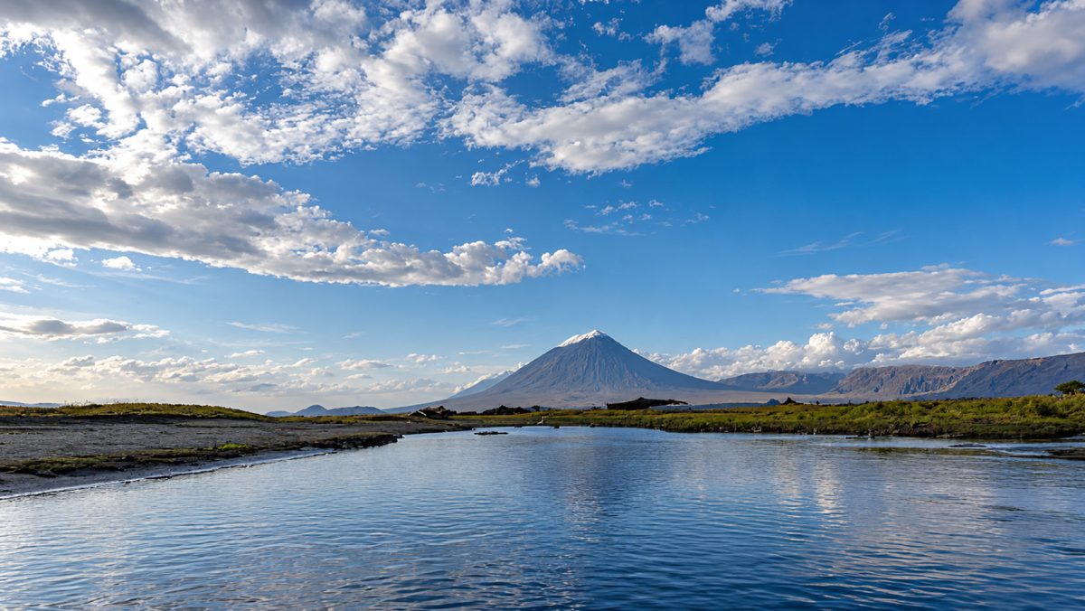
Lake Natron Tanzania looks like it should be empty. The water can run rust red, the shoreline crusts over with salt and the land surrounding it appears scorched by the sun. Yet hundreds of thousands of lesser flamingos may gather here when conditions are right, feeding and breeding in a lake that few other large animals can tolerate.
That contradiction is the reason to come. Lake Natron is beautiful, but not in the easy way of a forest, beach or wildlife-filled savannah. Its appeal comes from the heat, space, mineral colour and the cone of Ol Doinyo Lengai rising above the southern horizon. It feels geological before it feels scenic.
Where Lake Natron is located
Lake Natron sits in the Gregory Rift, the eastern branch of the Great Rift Valley, in the far north of Tanzania’s Arusha Region. It lies close to the Kenyan border, northeast of the Ngorongoro Highlands and south of Kenya’s Lake Magadi.
The settlement most visitors use as a base is Engaresero, near the lake’s southern end. From here, the Rift Valley escarpment rises to the west and Ol Doinyo Lengai dominates the country to the south.
The lake is fed by the Southern Ewaso Ng’iro River, which flows down from Kenya, as well as seasonal streams, rainfall and mineral-rich springs. What it does not have is an outlet. No river carries the water onwards to another lake or the ocean.
That missing outlet explains almost everything unusual about Lake Natron.
How Lake Natron formed and why the water turns red
The lake occupies a low basin created by the tectonic forces pulling apart the East African Rift. Water collects in this depression and then leaves mainly through evaporation. The dissolved salts and minerals stay behind.
Repeat that process over thousands of years and the water becomes increasingly saline and alkaline. Mineral-rich springs, volcanic rocks, ash and runoff from the surrounding catchment all contribute to the chemistry.
Ol Doinyo Lengai is part of that volcanic landscape, although the lake’s alkalinity cannot be attributed to the volcano alone. It comes from the wider geology of the basin combined with mineral inflow, a closed drainage system and intense evaporation.
The red and orange colour has a different immediate cause. Salt-tolerant microorganisms thrive in the lake’s most concentrated water. Their pigments can colour sections of the lake red, pink or orange, particularly when evaporation increases the concentration.
Lake Natron is not always red. It can appear white where salt has crystallised, brown around exposed mud, greenish in less concentrated water or silver beneath a clear sky. The colour changes with the water level, light, season and activity of the microorganisms.
How deep is Lake Natron?
Not deep at all, which surprises most first-time visitors.
Lake Natron is generally less than three metres deep and considerably shallower across much of its surface. Its size can still be immense because the water spreads across a wide, flat basin rather than filling a deep depression.
Both the depth and outline change with the seasons. Rain and river inflow can expand the lake across the surrounding flats. During drier periods, evaporation draws the water back and exposes mud, salt crust and isolated pools.
This is why two aerial photographs can make Lake Natron look like two different places. One may show a broad sheet of water. Another may show a fractured mineral landscape crossed by narrow red lagoons.
| Fact | Detail |
|---|---|
| Location | The Gregory Rift in northern Tanzania, close to the Kenyan border |
| Elevation | Approximately 600 metres above sea level |
| Depth | Generally less than three metres, with considerable seasonal variation |
| Lake type | A shallow, saline and highly alkaline terminal lake |
| Fed by | The Southern Ewaso Ng’iro River, seasonal watercourses, rainfall and mineral springs |
| Known for | East Africa’s only regular large-scale lesser flamingo breeding site |
Why flamingos can live here
Lesser flamingos are not simply enduring Lake Natron. They are using the conditions to their advantage.
They feed on microorganisms adapted to saline and alkaline lakes. When water levels are suitable, temporary mud and salt islands provide nesting areas separated from the shore. The surrounding water makes those colonies difficult for many land predators to reach.
Lake Natron is consequently the only place in East Africa where lesser flamingos regularly breed successfully in very large numbers. The wider population moves between alkaline lakes in Tanzania and Kenya to find food, but Natron remains critical to its breeding cycle.
The number visible to visitors changes. Water levels must be low enough to expose secure nesting areas but not so low that predators can cross to them easily. Food availability, salinity, disturbance and conditions at other regional lakes also affect where the birds gather.
There are periods when the lake appears lined with pink. At other times the birds are more dispersed or concentrated far from an accessible viewpoint. A visit should be planned around recent conditions rather than a promise that the same spectacle occurs every week of the year.
Does Lake Natron turn animals into stone?
No, not in the way the internet usually tells the story.
The myth became famous after photographer Nick Brandt found preserved birds and bats around the lake and positioned their bodies in lifelike poses for a photographic series. The images were deliberately eerie. They were not photographs of animals instantly petrified where they stood.
Lake Natron’s mineral-rich water can encrust or preserve the remains of animals that have already died. Its alkalinity can also irritate skin and eyes. Neither fact means a living bird touches the surface and immediately becomes stone.
The lake is also far from lifeless. Alongside flamingos and microorganisms, specialised fish and invertebrates survive in less extreme habitats around freshwater and hot-spring inflows. Wetlands at the margins support an additional range of birds and other wildlife.
Lake Natron is harsh, but “deadly lake” is too simple a description for an ecosystem supporting life found almost nowhere else.
Ol Doinyo Lengai, the mountain behind the lake
Ol Doinyo Lengai stands close to 2,962 metres above sea level and rises with almost theatrical abruptness from the Rift Valley floor.
Its name is commonly translated from Maa as the Mountain of God. The volcano holds deep spiritual significance for Maasai communities living in the surrounding landscape. It is not simply a dramatic peak placed there for visiting climbers.
Geologically, Ol Doinyo Lengai is unique. It is the only active volcano known to have produced natrocarbonatite lava in historical times.
This lava contains high concentrations of sodium and potassium carbonate and erupts at a lower temperature than the silicate lava associated with most volcanoes. Fresh flows can appear black or dark brown. After reacting with moisture, the material rapidly weathers into pale grey and white surfaces.
That transformation gives the upper mountain its strange, almost unfinished appearance. Photographs may resemble a landscape made from ash or old concrete rather than recently formed volcanic material.
The human footprints at Engare Sero
Flamingos and volcanic lava are not the only things preserved in this landscape.
Near Engare Sero, researchers have documented more than 400 ancient human footprints in volcanic sediment. Scientific dating places them between approximately 6,000 and 19,000 years old.
The prints were left by anatomically modern humans crossing wet ground. Volcanic material originating from Ol Doinyo Lengai had been moved and reworked by water, creating the surface into which they stepped. Later sediment preserved the impressions.
Some of the footprints form distinct trackways, allowing researchers to study walking speed, body size and possible group movement. They capture an ordinary human moment with extraordinary clarity: people crossing a wet landscape thousands of years before anyone thought of it as an archaeological site.
They should not be confused with the much older Laetoli footprints elsewhere in northern Tanzania. Laetoli preserves evidence of early hominins walking upright approximately 3.66 million years ago. Engare Sero belongs to a far more recent chapter of human history.
Can you visit Lake Natron?
Yes, and the difficult approach is part of why the area still feels remote.
The drive from Arusha occupies a substantial part of the day. Tarmac eventually gives way to rougher roads and tracks, with the final journey becoming increasingly dry, dusty and sparsely populated. Rain can alter the condition of these roads quickly.
A four-wheel-drive vehicle is the sensible choice. Lake Natron is not the place to save money by testing whether an ordinary road vehicle can manage the final section.
Accommodation is concentrated near the lake’s southern end and around Engaresero. There are fewer camps and lodges than in the Serengeti or Ngorongoro, but enough variety for Lake Natron to be incorporated into a properly planned northern circuit.
Two nights work well for most visits. Arrival takes much of the first day, leaving a full day for the lake, waterfall, landscape and community activities before moving onwards.
What is there to do around Lake Natron?
The lakeshore walk is usually the starting point. A local guide selects an appropriate route according to water levels, bird locations and the stability of the ground. The objective is not to walk as close to the flamingos as possible. A distant viewpoint and binoculars are better than disturbing a breeding or feeding group for a photograph.
The Ngare Sero waterfall provides an unexpected change of scenery. The walk follows a gorge into the escarpment, where freshwater, vegetation and shaded rock replace the exposed lake basin. Depending on current conditions, the route may involve shallow water and slippery sections.
Community-based visits can introduce the daily life of the people who inhabit this apparently empty landscape. These experiences are better when arranged as genuine local encounters rather than brief staged stops added to fill an itinerary.
Sunrise and late afternoon are valuable simply for being outside. Ol Doinyo Lengai changes shape as shadows move across it, while the lake shifts from mineral white to pink, copper and silver.
Climbing Ol Doinyo Lengai
The volcano climb is optional, and it should remain optional.
Its altitude is modest compared with Kilimanjaro, but the trail is steep, loose and physically unforgiving. Volcanic ash and gravel move beneath the feet, secure footing can be limited and the descent places sustained pressure on knees and ankles.
Climbers commonly leave around midnight to avoid the most intense daytime heat and reach the upper mountain during the morning. It is an unusual experience: hours of darkness, a small pool of light from a head torch and the slope continuing upwards beyond it.
The complete outing can occupy most of the night and morning. Timing varies according to fitness, route condition, weather and how far the guide considers it safe to proceed.
People often describe the climb as far harder than expected. That is not because it reaches extreme altitude. It is because the gradient rarely relaxes and the loose surface makes both ascent and descent tiring.
Good fitness, reliable footwear and strong legs are essential. Anyone with knee or ankle problems, difficulty on steep terrain or limited hiking preparation should think carefully before attempting it.
Ol Doinyo Lengai is active, so access and summit conditions must always be assessed using recent information. Reaching the top is never more important than respecting a decision to turn around.
When is the best time to visit?
The drier months generally provide firmer road conditions and easier walking. June to October is a common travel period, with January and February providing another potentially drier window.
The Lake Natron basin can become extremely hot. Walks are better arranged in the cooler morning or later afternoon, while the volcano climb begins at night partly to avoid the strongest daytime heat.
Rain makes the roads and shoreline more difficult, but it does not make the landscape less interesting. The lake expands, seasonal streams strengthen and dry hills can turn green surprisingly quickly.
Flamingo breeding cannot be reduced to one guaranteed month. Suitable water levels and salinity matter more than a date printed in a brochure. Anyone travelling primarily for the birds should ask what has been happening at the lake recently.
Is Lake Natron safe to visit?
Yes, when the environment is treated with the respect it requires.
The lake itself is not suitable for swimming. Concentrated water can irritate skin and eyes, while apparently solid salt crust may conceal soft mud beneath it. Follow the route chosen by the local guide rather than walking independently towards the water.
Heat and dehydration are more ordinary but equally important concerns. Carry sufficient water, wear a hat, use sun protection and avoid planning the most strenuous activity for the hottest part of the day.
The Ngare Sero waterfall is the freshwater alternative, although current conditions should still determine where walking or swimming is advisable.
How Lake Natron fits into a wider safari
Lake Natron rarely works well as a hurried overnight diversion. The drive is too significant and the landscape too unusual to justify arriving late and leaving immediately after breakfast.
It can be connected with Ngorongoro and the Serengeti, particularly when the route, season and Serengeti entry point are considered together. Another possibility is combining it with Lake Eyasi for a journey placing greater emphasis on Rift Valley landscapes and culture.
Travellers prioritising lions, elephants and dense concentrations of wildlife should see Lake Natron as an addition to the major safari parks, not a substitute for them. Its appeal lies elsewhere.
The rough road is the main reason people hesitate to include it. It is also the reason Lake Natron remains quieter than the better-known northern destinations. That is the trade-off: several uncomfortable hours in return for a landscape that has not been polished into something easier.
When the afternoon heat finally drops, Ol Doinyo Lengai darkens against the sky and flamingos move across water the colour of rust. The lake no longer looks empty. It looks like a place where life has learned different rules.